点击按钮跳转至开发者官方下载地址...
Explore and plan your boating trips on your Mac, then export your route to your iPhone for navigation while at sea - or plug in a GPS unit, and navigate with your laptop and our hi-res vector charts.
SeaNav for Mac has the latest NOAA ENC Digital Vector Marine charts covering the whole of the USA and Great Lakes.
- Includes US Coastal, Great Lakes and USACE Inland Charts.
- Buoys, lights etc. are tappable with bearing and distance.
- Seamless fast panning and zooming across charts.
- Route Planning and tracking with Waypoints, SOG, COG, ETA etc.
- Charts work offline
- Route export, import and sharing
- Live AIS Ship positions
- Share routes with SeaNav on iOS
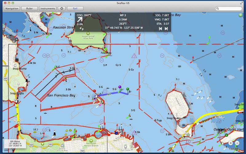
SeaNav uses the latest Digital Vector charts providing a wealth of benefits and advantages over raster charts. Buoys, Lights, Bridges, Depth Contours, Depth Soundings, Rocks, Anchorage areas, NOAA Weather Buoys etc. are all selectable and have real time distance, bearing and detail information. Turn off layers to de-clutter the display and only show what is important at the time. Tides, moon and sun times and weather are also all available at your fingertips.
SeaNav lets you measure distances and bearings and record waypoints on routes. When at sea, the app’s Sailing HUD shows your position, Course over ground (COG), Speed over ground (SOG), Vector Made Good (VMG), Estimated Time of Arrival (ETA), Distance and bearing to next Waypoint. Waypoint reached alerts, auto-routing to the next waypoint and collision alerts.
SeaNav is also available for iOS, so you can plan a route on your Mac and share the route with your iPhone or iPad.
Real-time route navigation requires a GPS location.
Inexpensive 3rd Party units are available to add these accurate location capabilities to your device. SeaNav works with Bluetooth and serial GPS units, and those which provide location or AIS service via TCP or UDP or TCP, including devices from Lowrance, Simrad and B&G GoFree.
Your purchase of SeaNav includes 12 months free updates to the included US chart set.
Our Privacy Policy may be accessed via http://seanav.net/privacy.php
GPS only required for real time route navigation. Optional Real time AIS, Tides and Weather information require an active internet connection.
Please note that continued use of GPS running in the background can dramatically decrease battery life.
NOT FOR NAVIGATION
This program is distributed in the hope that it will be useful. SeaNav should only be used for basic navigation reference and should not be solely relied upon to determine precise locations, proximity, distance, or direction.
Third Party Licenses and Notices
NOTICE: US Marine Charts are derived from official NOAA Electronic Navigational Charts.


