点击按钮跳转至开发者官方下载地址...
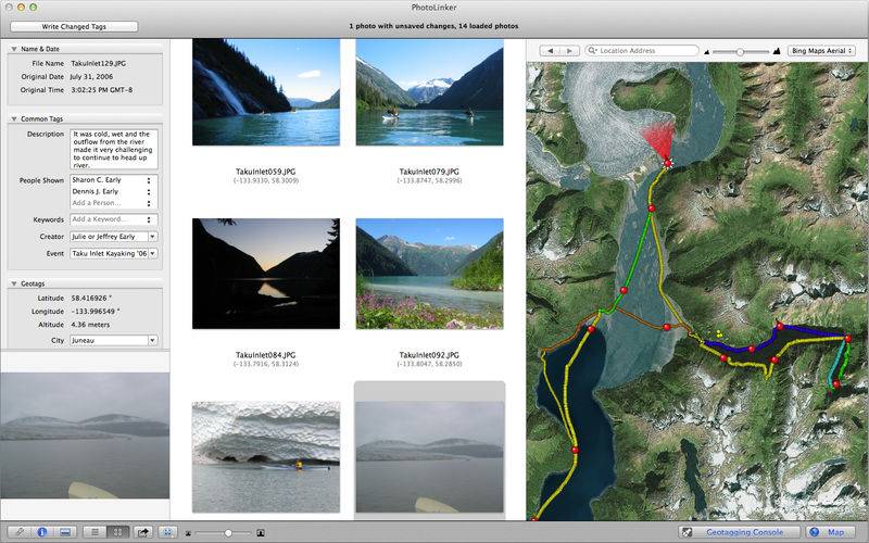
PhotoLinker provides an unprecedented level of map, GPS track and photo tag interactivity, making photo annotation a compelling project and not a dreadful chore. Whether your photos are geotagged using PhotoLinker or automatically geotagged using your camera, PhotoLinker lets you interact with and explore your photos on a variety high quality maps. Metadata Working Group compliance ensures that your annotations are read from and written to your photos using new industry standards.
Map your photos and explore your tracks
• Explore your geotagged photos on a variety of high quality maps
• Add and display image direction
• Fine tune the image direction added by your camera
• Explore your GPS track history on a variety of maps
• View information about individual track points or the entire track
• Stylize your tracks and waypoints choosing size, border and fill color
Annotate your photos
• Customize the metadata editor to use exactly the tags you want
• Regroup, reorder, and rename tags to streamline your workflow
• Track exactly how your photos' metadata will be modified
• Choose from roughly 100 industry standard tags such as title, people and keywords
• Ensure your photo metadata complies with Metadata Working Group standards
• Write tags directly to the photo, its sidecar or both
• Tags are read and written with the excellent open source tool ExifTool
• Support for jpeg and most RAW file formats including XMP sidecar files
Geotag your photos
• Drag in GPS tracks and photos; immediately view proposed geotag locations
• Watch proposed locations change instantly as you adjust the photo time or time zone
• Choose from array of advanced criteria for determining which photos are geotagged
• See exactly where the photos will be before you hit the geotag button
• No GPS track? Drag a photo from browser to map and boom!, you've geotagged your photo
• Automatically fetch city, state, and country tags
Advanced date tools
• Incorrect time on your camera? PhotoLinker makes correction easy
• Add dates to scanned photos
• Copy dates between tags
• You can even set the Finder's file creation date to the date the photo was taken
iPhoto and Aperture
• Drag in photos from iPhoto or Aperture to annotate and geotag
• Write changes to the photo and sync back to iPhoto
Share and Showoff your adventures
• Built-in slideshow with a customizable map featuring your tracks and photo points alongside
• Export resized images containing all of the correctly formatted metadata
• Export photo metadata in a number of formats


